Projects · Upper Sindh
A 400-acre industrial enclave proposed in District Sukkur, on the left bank of the Indus near Rohri, beside the Sukkur–Multan Motorway. Planned for medium industrial clusters, under public–private partnership.
Planned
- 400
- acres identified
- 2.6 km
- to the M-5 motorway interchange
- 18 km
- to Sukkur Airport
01Region
Sukkur lies where Sindh, Balochistan and Punjab converge. National highway, CPEC and rail routes meet here, and around eight districts are 30 to 45 minutes away.
It is a major centre of agricultural production: cotton, sugarcane, wheat and rice, with orchards of dates and other fruit.
Sukkur already has two industrial estates: the Sindh Industrial Trading Estate, set up in 1963 over about 1,060 acres, and the 110-acre Small Industries Estate. The new enclave is planned as a modern, purpose-built addition.
- Cotton
- Sugarcane
- Wheat
- Rice
- Dates
- Bananas
Sources: SEZMC projects presentation, slide 18; sezmc.gos.pk.
02Connectivity
Every link SEZMC’s plans measure, nearest first: from the railway and the motorway at the gate to the ports of Karachi and Gwadar. Filter by kind of link.
- Rail ML-1 main railway line 2.5 km Pakistan’s main north–south railway. Location study
- Road M-5 motorway interchange 2.6 km The Sukkur–Multan Motorway runs along the site, with three gates planned on its side. Master plan, June 2025
- Rail Rohri railway junction 5.3 km Approximate distance, as marked on the plan. Master plan, June 2025
- Utilities 220 kV grid station (NTDCL), Rohri 6.7 km Approximate distance, as marked on the plan. Master plan, June 2025
- Region Sukkur city 15 km The divisional headquarters across the Indus. Location study
- Air Sukkur Airport 18 km Domestic airport. Location study; master plan
- Road Rato Dero, CPEC central route 65.5 km The central route of CPEC towards Khuzdar and Gwadar. Master plan, June 2025
- Road Ghotki–Kandhkot bridge 70 km Crossing of the Indus upstream. Location study
- Region Punjab–Sindh border 130 km Gateway to Punjab’s markets. Location study
- Ports Karachi Port 450 km Sindh’s main seaport. Master plan, June 2025
- Ports Gwadar Port 1,100 km Import and export gateway via the central route of CPEC. Master plan, June 2025
Distances are approximate, as printed on SEZMC’s location study and the June 2025 master plan. The scale grows with distance.
03Site and master plan
SEZMC’s location study mapped parcels of state land near Rohri. The June 2025 master plan lays out 400 acres beside the Sukkur–Multan Motorway.
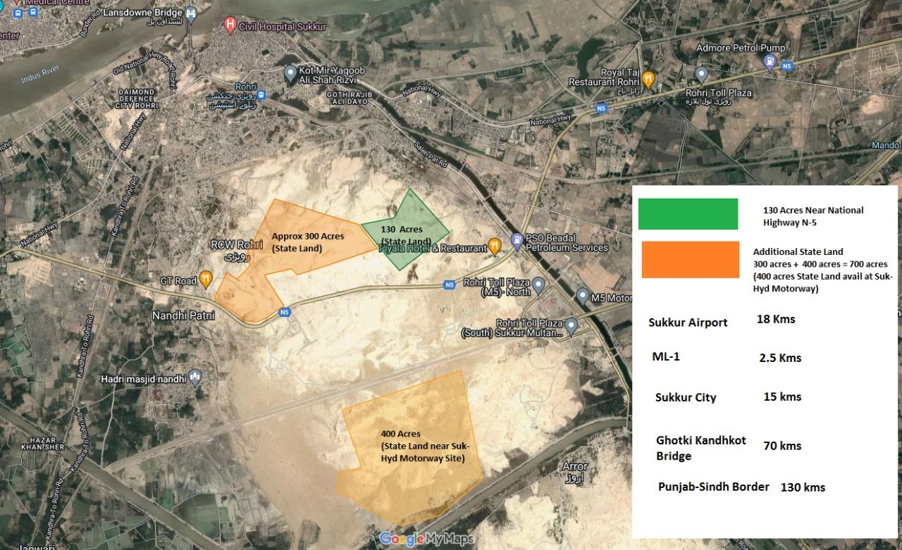
- 130 acres
- State land near National Highway N-5
- About 300 acres
- State land
- 400 acres
- State land near the Sukkur–Hyderabad motorway site
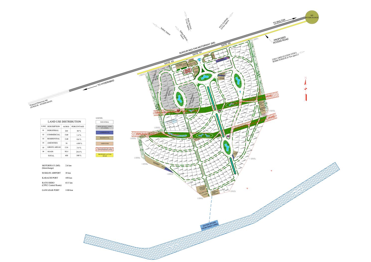
400 acres in the master plan
| Land use | Acres | Share |
|---|---|---|
| Industrial | 264 | 66% |
| Commercial | 5.6 | 1.4% |
| Residential | 2.4 | 0.6% |
| Amenities | 16 | 4% |
| Green areas | 13.6 | 3.4% |
| Roads | 98.4 | 24.6% |
04Industrial clusters
SEZMC plans the enclave for medium industrial clusters, such as:
-
01
Gem processing
-
02
Apparel and garments
-
03
Halal food processing
Source: sezmc.gos.pk.
05Planning status
Steps SEZMC has published, and the next step it describes. No completion date has been announced.
-
Done
Land identified
400 acres in District Sukkur.
-
Done
Approved by the SEZMC Board
A new industrial enclave under public–private partnership.
-
Done
Consultant selected
For feasibility studies and transaction advisory services.
-
Done
Master plan published
400 acres, June 2025.
-
Next
Developers and enterprises invited
Solicitation under the public–private partnership framework.
Source: sezmc.gos.pk; SEZMC projects presentation, slide 18.
Developers and enterprises: tell the Investor Desk what you plan, the land and utilities you need and your timeline.